This story originally appeared in The Guardian and is republished here as part of Covering Climate Now, a global journalism collaboration strengthening coverage of the climate story.
The winning photographers of the Getty Images Climate Visuals photography grant, Aji Styawan and Greg Kahn, on opposite sides of the world, captured the stories of the impact of rising sea levels in Indonesia and the US and the resilience with which communities have responded.
Their local knowledge, individual photographic style and cultural sensitivity shone through to the grant judges. Both reveal restrained emotion and a surreal sense of place.
The landscape, communities, political structures, religions and people these photographers work with are diverse. Their proposals and photography work impressed the jury and embraced the Climate Visuals seven principles for impactful photography.
In the photo above taken by Aji Styawan, a resident of Sayung subdistrict in Demak, Indonesia, slowly makes his way through the inundated streets of the village due to rising sea levels.
Drowning Land by Aji Styawan
Indonesia is one of the largest archipelago nations in the world, with more than 17,000 islands. The majority of the small islands are only a metre above sea level. Deforestation, land reclamation and groundwater extraction make these areas even more vulnerable to rising sea levels.
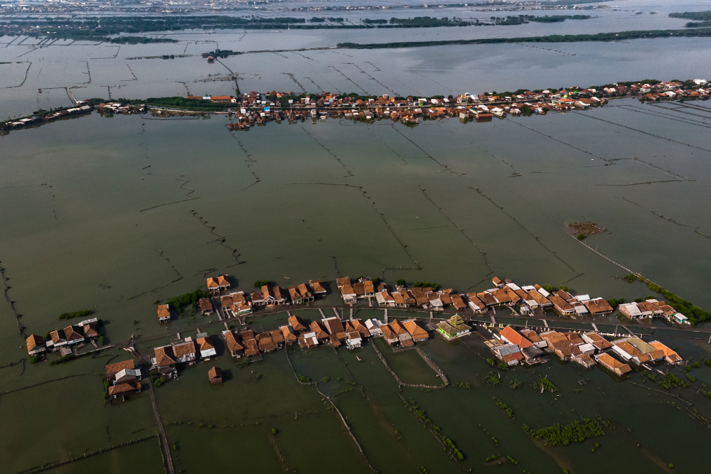
January 2020 - Sayung subdistrict, Demak, Central Java, Indonesia.
Aerial photo of the villages in northern coast of Sayung subdistrict in Demak Regency, surrounded by water due to rising sea levels. Not only has the coastline been eroding through the process of erosion, but land subsidence of around 10 centimeters a year make this area extra vulnerable to climate change. Demak used to be surrounded by fertile land. As the sea approached closer, a development that started around 1995, agricultural land gradually became fish ponds, to the point where now the land is fully submerged by all sea. The villagers, once farmers, became fishermen. (The Guardian/Aji Styawan/Getty Images Climate Visuals Grant Recipient)
Experts predict that before 2050, thousands of small islands and millions of houses in coastal areas across Indonesia will disappear due to rising sea levels.
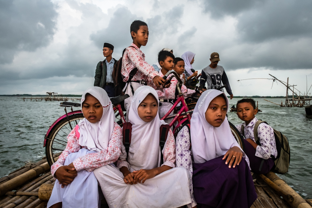
January 2020 - Sayung subdistrict, Demak, Central Java, Indonesia. Early morning, a raft boat takes students across a flooded area to a road from where they can go to school. Their usual road to school collapsed due to abrasion caused by rising sea Levels. (The Guardian/Aji Styawan/Getty Images Climate Visuals Grant Recipient)
Demak is on the northern coast of Central Java, about 300 miles east of Jakarta. More than 500 households have been displaced in the past 20 years.
As the sea levels rose, farmland became fish ponds and mangrove forests, which are now also submerged. Today it's all sea.
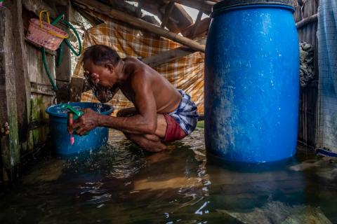
Sayung subdistrict, Demak, Central Java, Indonesia. Rozikin (57) brushed his teeth and washes up inside his bathroom, which is flooded due to the rising sea levels. Local villagers learn to survive even though their lives are threatened by rising sea levels. (The Guardian/Aji Styawan/Getty Images Climate Visuals Grant Recipient)
July 2018 - Sayung subdistrict, Demak, Central Java, Indonesia. At a public cemetery a tomb is protected from coastal erosion by rock filled bags. When
alive, the residents live with the water, they are surrounded by it, even inside their homes. When they die they are buried in the land submerged by the rising sea. (The Guardian/Aji Styawan/Getty Images Climate Visuals Grant Recipient)
3 Millimeters by Greg Kahn
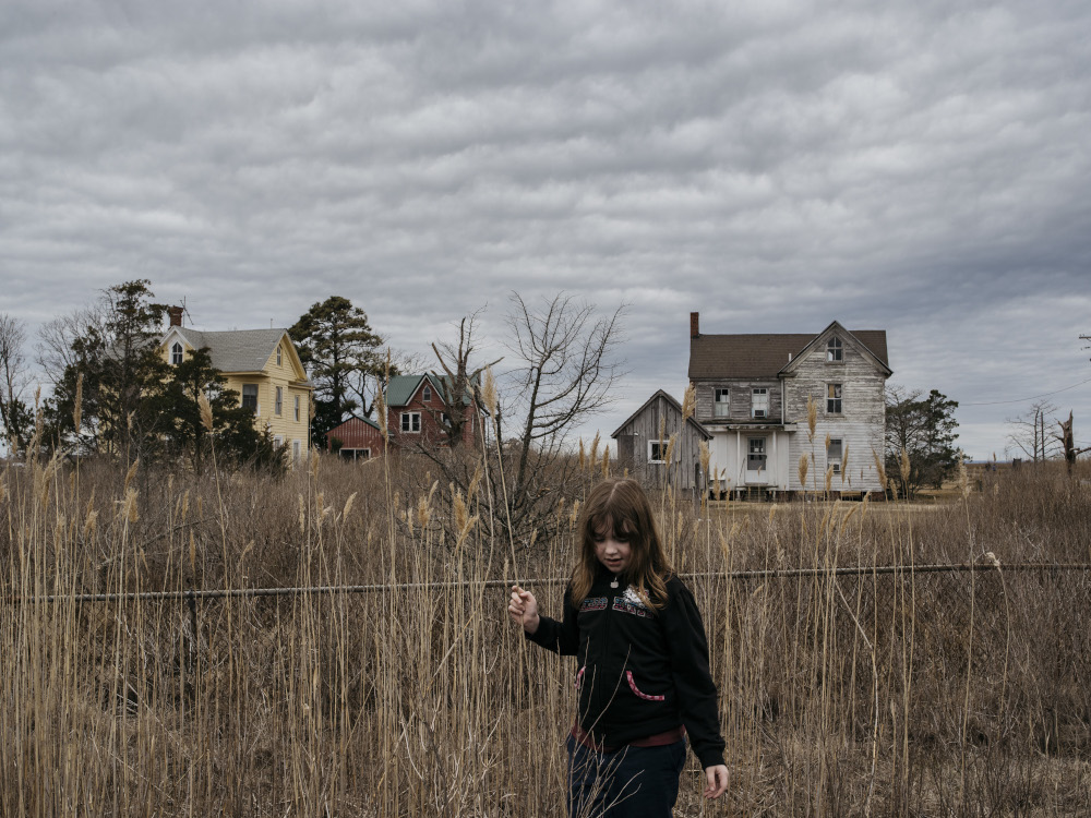
Three extra millimetres of water every year will make land vanish. It will swallow communities. It will change environmental habitats forever. It will cause record pollution. For townspeople along the inner coastal region of the Chesapeake Bay in Maryland, the impact of sea level rise is no longer an abstract worry debated by politicians. They see the land becoming more saturated beneath their feet. Thirteen of the bay's southern islands, many of them once inhabited, are gone.
April 2013. A black rat snake slithers across Maple Dam Road in Church Creek, Md. Many homes in the area of Church Creek, which neighbors Blackwater National Wildlife Refuge, have been abandoned as the soil becomes more saturated with salt water and turns into Marsh. (The Guardian/Greg Kahn/Getty Images Climate Visuals Grant Recipient)
3 Millimeters explores the waterways of Maryland, where, due to the region's makeup and Atlantic Ocean flow, sea levels are rising twice as fast as the global average and will leap by as much as 5ft by 2100. This will submerge more than 250,000 acres of land, displacing more than half a million people. Farms once fertile and productive now wilt as mounting salinity levels force families to abandon their way of life.
October 2013 From above, water from the Chesapeake Bay intrudes on the marsh of Blackwater National Wildlife Refuge on the Eastern Shore of Maryland, killing trees and drowning the land in its path. (The Guardian/Greg Kahn/Getty Images Climate Visuals Grant Recipient)
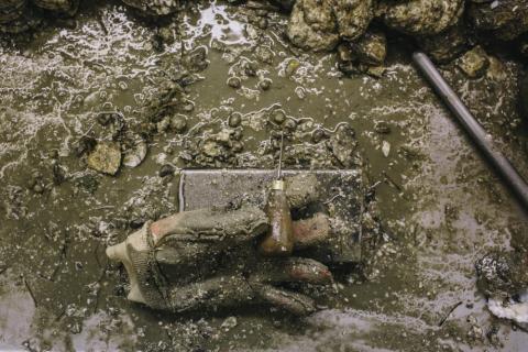
February 2014. A glove from an oyster shucker is covered in so much sand an mud that it retains it's shape even when the shucker goes on a break. (The Guardian/Greg Kahn/Getty Images Climate Visuals Grant Recipient)
There is nothing to stop Hoopers Island from slowly drowning. Locals point 100 yards into the bay, telling stories of a baseball field where they used to play. Graves containing the island founders, once buffered by a forest, now jut out from an eroding shoreline patched with makeshift rock walls. "I doubt there'll be any human life here in 100 years," said Donald Webster, who works for the Maryland Department of Natural Resources.
While nothing can reverse rising seas in places like Smith Island, there is hope for others. Gradient sea walls, vegetation renourishment and public education are all trying to preserve natural habitat and homes along the coast. The hope is that it will stop erosion as well as maintain habitat for sealife such as horseshoe crabs and terrapins.
March 2016. Second-grader Kimberly Corbin, 7, plays at recess at Ewell School on Smith Island in Maryland on March 11, 2016. The school, located on the last inhabited island in the Chesapeake Bay in Maryland, has nine students. (The Guardian/Greg Kahn/Getty Images Climate Visuals Grant Recipient)